produits
Contact:
Easy Tunnel
Axis3D ETU - Easy Tunnel
Field solutions for geometry-based stakeout and control measurements
 Flexible measurements: Stakeout and control
 wherever it’s needed - with the design geometry loaded on-board the total station.
Short measuring times: Automatic positioning to target by iterating minimizes setout and scanning time.
Intuitive user interface: Workflow optimized for fieldwork developed by surveyors for surveyors.
No additional hardware: On-board software for Leica Geosystems total stations TPS1200, TM/TS30 and Viva.
Setup and Orientation
Stakeout
Controls
 The total station position is calculated using standard Leica functions. Observations are then made to reference points for post-processing of position, height and orientation of the instrument. Assigning point IDs and
positioning to targets can be automated.
The total station position is calculated using standard Leica functions. Observations are then made to reference points for post-processing of position, height and orientation of the instrument. Assigning point IDs and
positioning to targets can be automated.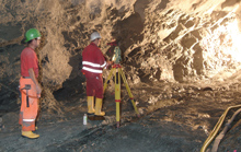 The design geometry is exported from Axis3D COS office software and loaded onto the total station. On site, points are set out relative to the design geometry with Axis3D ETU using stationing, height, or offset values from centerline, profile arc length, or radial distance from nominal profile. Furthermore, it is possible to stake out the
intersection point of any given 3D line with the design geometry.
The design geometry is exported from Axis3D COS office software and loaded onto the total station. On site, points are set out relative to the design geometry with Axis3D ETU using stationing, height, or offset values from centerline, profile arc length, or radial distance from nominal profile. Furthermore, it is possible to stake out the
intersection point of any given 3D line with the design geometry.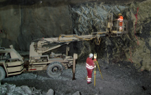 For as-built checks coordinates of single points can be viewed directly on site, either in reference to the center line or to the nominal profile. The automatic linescan of as-built profiles – with the added option of omitting certain areas such as ventilation ducts – enables quick, comprehensive control. Each scan point is positioned automatically by an iteration, to find the correct chainage and arc-lengh.
Functionality
Applications
General
- Axis3D ETU operates with the entire design geometry, including profile enlargements, loaded onto the total station (exported from Axis3D COS). Pre-calculating stakeout points is unnecessary.
- Making use of Leica Viva Imaging functionality (coming soon)
- Save all program settings
- Measurement data and coordinates stored in ASCII files in Leica GSI8 or GSI16 format
- Point coding consistent with other Axis3D products
- Optional: logging of all activities on the total station
- Program continues after power fail
- Unlimited number of reference points
- One- or two-face measurements
- Automatic detection of point IDs for manual measurements
- Automatic positioning after entering point ID
- Automatic target recognition measurement using pre-defined target heights and reflector constants
- All target points stored for repeat measurements
- 1D, 2D, 3D stakeout relative to center line (chainage, horizontal and vertical offset)
- 1D, 2D, 3D stakeout relative to nominal profile (chainage, arc length, radial offset)
- Automatic point IDs
- Measure to prisms or reflector-less
- Optional: automated iteration to target
- Automated repetition of reference point readings
3D Line Stakeout
- Stakeout intersection points of 3D lines
- Automatic point IDs
- Measure to prisms or reflector-less
- Optional: automated iteration to target
- Automated repetition of reference point readings
Profile Scan
- Profile scan within a given chainage range
- Freely define profile intervals and point spacing in profile
- User defined scan areas within a profile
- Automatic point IDs
- Reflector-less measurement
- Optional: automated iteration to target
- Automated repetition of reference point readings
Point Checks
- Check relative to center line (chainage, horizontal and vertical offset)
- Check relative to nominal profile (chainage, arc length, radial offset)
- Automatic point IDs
- Measure to prisms or reflector-less
- Optional: automated iteration to target
- Automated repetition of reference point readings
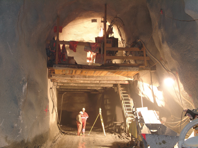
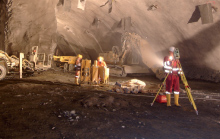
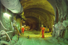 Tunneling
Stakeout and control of center lines, steel arches, lining, profile enlargements, niches, side-ways, formwork, etc.
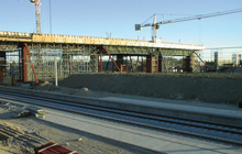 Road and Rail Construction
Stakeout and control of center lines, prefabricated slabs, side-ways, plane layer, dams, cuts, installations, etc.
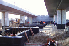 Building Construction
Stakeout and control of center lines, foundations, abutments, formwork, boreholes, retaining walls, etc.
.
System Information
Hardware
- Leica Geosystems TPS1200 total station
- Leica Geosystems TM/TS30 total station
- Leica Geosystems Viva total station
- Leica Geosystems Nova total station
Software- Axis3D ETU on-board software for Leica TPS1200, TM/TS30, Viva and Nova total stations
Related Products
- Axis3D COS - Construction Surveying
- Axis3D NET - Network Adjustment
- Axis3D SET - Sets of Angles
Customers
DIBIT Measuring TechniqueRhomberg Sersa Rail Group
Vorarlberger Illwerke AG
pour la géodésie et la métrologie industrielle
PC | Internet | Systèmes mobiles| Systèmes embarqués | Visualisation 3D