Contact:
Axis3D GTM and Axis3D MON:
Fast measurements and superior graphics in the name of hydroelectric power
From 2002 to 2009 one of Europe’s largest hydro power projects was hidden away in a narrow valley in the Austrian state of Vorarlberg – under ground. For the duration of the construction project both the developer’s and the power station owner Illwerke AG’s surveying teams relied on two systems from significant software for their geotechnical measurements : Axis3D MON was used for measurements while Axis3D GTM provided reliable coordinates and graphical information after processing.„Axis3D MON allowed us to choose the most efficient method for the current measurements on site, every day.“
Boris Schukoff, Head of Geotechnical Measurement Team
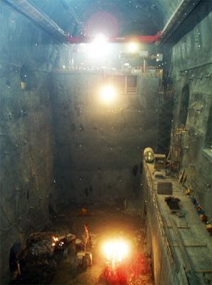 Three machine towers, each 40m high, weighing hundreds of tons and consisting of turbine, generator, and pump,
produce peak power at Vorarlberger Illwerke AG's hydroelectric power plant "Kops II". They are housed in a giant cavern
in the mountain connected to a tunnel system which is many kilometers long. "During construction we took three-dimensional trigonometric
deformation measurements, as well as readings of 3- and 5-point extensometers, and anchor load cells. This meant measuring 290 points
daily in the cavern alone." Boris Schukoff, head of the geotechnical measurement team on site, explains. Difficulties accessing and
maintaining targets, many very steep sightings, and time pressure from ongoing construction were among the challenges the surveyors faced.
Three machine towers, each 40m high, weighing hundreds of tons and consisting of turbine, generator, and pump,
produce peak power at Vorarlberger Illwerke AG's hydroelectric power plant "Kops II". They are housed in a giant cavern
in the mountain connected to a tunnel system which is many kilometers long. "During construction we took three-dimensional trigonometric
deformation measurements, as well as readings of 3- and 5-point extensometers, and anchor load cells. This meant measuring 290 points
daily in the cavern alone." Boris Schukoff, head of the geotechnical measurement team on site, explains. Difficulties accessing and
maintaining targets, many very steep sightings, and time pressure from ongoing construction were among the challenges the surveyors faced.
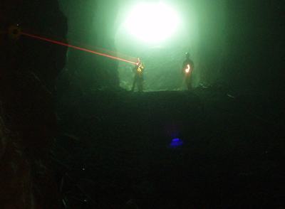
"By using the total station software Axis3D MON we were able to work quickly and with high accuracy, saving ourselves the trouble
of time-consuming manual measurements with a diagonal eyepiece to the many steep sightings," says Schukoff. Axis3D MON can
automatically position to and measure point groups and individual points. Temporarily hidden points are automatically
re-measured, and manually measured points are automatically assigned their correct point IDs. The project included more than
400 points, which were all stored on theTPS, and new points could be added with ease. Schukoff explains: "Having a variety of
ways to change the measurement method during measurements without exiting the program was important to us. We always chose
the most efficient method for each measurement on site."
Not even the geotechnical engineers' special requests could slow us down."
Boris Schukoff, Head of Geotechnical Measurement Team
In the office the surveyors relied on the analysis and graphics software Axis3D GTM. A number of stations
had to be linked during post processing to evaluate the measurements. With Axis3D GTM these stations could be
connected and automatically interpreted in one go. The tried and tested calculation algorithms made the often
complicated measurement geometries manageable, allowing for a fast and reliable coordinate calculation, with results
automatically stored in the deformation database.
 Surveyors on site were able to define the structure of the database to meet the requirements of the project as it
progressed. Schukoff is pleased with the system: "Without the ability to structure the data easily and flexibly we
never could have kept track of all the information from more than 40 tunnels, caverns, and shafts."
Surveyors on site were able to define the structure of the database to meet the requirements of the project as it
progressed. Schukoff is pleased with the system: "Without the ability to structure the data easily and flexibly we
never could have kept track of all the information from more than 40 tunnels, caverns, and shafts."
Axis3D GMT's ease of visualization garners more praise from Schukoff:
"The software allowed us to quickly generate graphics tailored to the specific needs of different users, e.g. our geotechnical
engineers or geologists. Within minutes and at the press of a button we were able to deliver the required graphics as a PDF file.
The usual requests such as changes to scale factors or color assignments could easily be fulfilled with the program's comprehensive
configuration options."
Client: Vorarlberger Illwerke AG
Project: New construction of pumped-storage hydroelectric power plant Kops II. Cavern power station 88 m x 30.5 m x 60.5 m. More than 40 tunnels, caverns, and mine shafts.
Project task: Geotechnical measurements of the cavern power station and the system of caverns; daily survey of up to 410 points; GTM generated graphics for various user groups.
Duration: 6 years
Software/Hardware: Axis3D GTM; Onboard-Software Axis3D MON with Leica TPS1200
Staff: 1 professional surveyor, 1-2 survey technicians
for Geodesy and Industrial Metrology
PC | Web | Mobile Systems | Embedded Systems | 3D-Visualization