Contact:
Axis3D AMO - stand alone, flexible monitoring
A busy highway tunnel, an assembly hall with a 300-ton crane, and a landslide threatening nearby houses – three projects that could hardly be more different but all have one thing in common: a successful installation of the automatic monitoring software Axis3D AMO. The flexibility and user definable functionality, as well as the quick and easy installation of the system within a few hours, convinced the respective clients of the advantages of Axis3D AMO.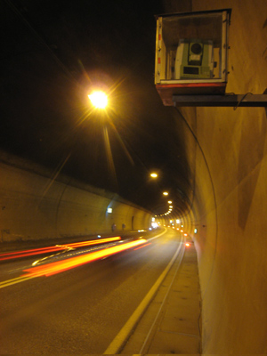 Highway Tunnel
When a landslide threatened to damage the dual tube highway tunnel Niklasdorf, the owner was forced to act. Automatic three-dimensional monitoring of the most affected areas of the tunnel was chosen to ensure continued traffic safety. A stable and immediately available system was needed that would not hinder traffic flow and that could withstand the harsh conditions in the tunnel (dirt, water) for years to come.
A Leica TCA1201 total station equipped with Axis3D AMO was installed in the tunnel and connected to the engineering office via GPRS for remote communication. Axis3D AMO has been measuring all 46 defined deformation points continuously every two hours since its installation in 2008 , calculating point coordinates using current refraction conditions in the tunnel. In spring 2009 the measured deformation exceeded the allowed monitoring limits and the tunnel tubes were closed before traffic safety was compromised. The damages were then repaired so the tunnels could be re-opened to traffic.
300-Ton Crane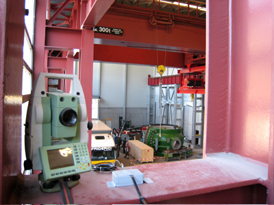 Due to settlement of an assembly hall, the owner, a power plant operator, was concerned about track deformations of the hall’s 300-ton crane. A system for three-dimensional monitoring of the crane supports, in particular of changes in track gauge and vertical displacement of the crane tracks, was needed.Axis3D AMO was up and running within a mere four hours, including test runs; the actual set up took just one hour. Since its installation , Axis3D AMO has been measuring sets to 21 targets continuously every four minutes . Results are displayed on a screen in the assembly hall in real-time, allowing instantaneous reactions should any changes occur.
Landslide
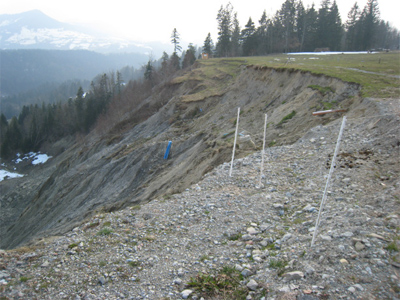
In 2007 an unexpected slope slump just below the town of Doren endangered
a number of houses and triggered a state of alert with authorities and residents, alike.
On behalf of Wildbach- und Lawinenverbauung (Avalanche Protection and Torrent Control) Axis3D AMO was installed within two hours. At first the total station was temporarily set up on a tripod; however, within six months a cement pillar was built to enable longer-term measurements.
The total station operated independently over the course of three years, defying freezing temperatures and snow throughout the winter months. Solar cells provided power and GPRS enabled wireless communication.
During quiet periods the slope moved a few centimeters a year. During active periods however, the slump rate was a few meters a day. The main responsibility of the engineers measuring the slope was to monitor the scarp in order to identify new movement as early as possible (alarm function). A long-term goal of the measurements is was also to gain a better understanding of the movements occurring here. Axis3D AMO
delivered the necessary results, in four-hour intervals, despite sighting distances of 10 to 1000m, and the associated difficulties with refraction.
for Geodesy and Industrial Metrology
PC | Web | Mobile Systems | Embedded Systems | 3D-Visualization